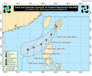
According to the state weather bureau, Tropical Depression Salome may hit or approach Batanes on Wednesday evening, causing Tropical Cyclone Wind Signal No. 1 to be hoisted in parts of Luzon.
“Strong winds and heavy rainfall are possible, with about 50 to 100 millimeters of rain expected in the Batanes area,” Philippine Atmospheric, Geophysical and Astronomical Services Administration (PAGASA) meteorologist Leanne Marie Loreto said during a 2:00 p.m. press briefing in Filipino.
“When we experience this level of heavy rainfall, flash floods and landslides are possible,” he said.
According to PAGASA's 2:00 pm bulletin, Salome, which developed into a tropical cyclone a few hours earlier, was located 255 kilometers northeast of Basco, Batanes and is moving almost steadily.
It has maintained its strength, with maximum sustained winds of 55 kilometers per hour (kph) near the center and gusts up to 70 kph.
PAGASA has hoisted Signal No. 1 in some areas of Luzon where strong winds are expected within 36 hours. These areas include Batanes, the western part of the Babayan Islands, and the northwestern part of Ilocos Norte, including the cities of Bangui and Laoag.
If Salome turns into a tropical storm, the bureau is also not ruling out the possibility of raising Signal No. 2, where hurricane-force winds are expected.
During the forecast period, PAGASA warned of very rough sea conditions, especially along the coasts of Batanes, Babayan Islands and Ilocos Norte.
PAGASA advised all types of sea vessels, especially small sea vessels, to take precautionary measures. , Age Adrian A Eva